Local introduction
Local introduction:
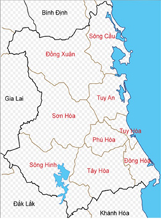
- Hoa Thang is a plain commune of Phu Hoa district, with National Highway 25 passing through the commune in the East-West direction, from Tuy Hoa city to the Central Highlands provinces, 3.5km from the center of Phu Hoa district to the East. The North borders Hoa Tri commune, Hoa Quang Nam commune - Phu Hoa district, the South borders Ba river - Tay Hoa district, the East borders Hoa An commune - Phu Hoa district, the West borders Phu Hoa town and Hoa Dinh Dong commune - Phu Hoa district, the total natural area is 1,741.66 ha, accounting for 6.18% of the natural area of the whole district. Administratively, there are 5 villages, including Phong Nien village, Phu Loc village, My Thanh village, My Hoa village and Dong Loc village. The whole commune has 5,732 households, with 21,138 people. The commune has 2 agricultural service cooperatives, 1 People's Credit Fund; 1 Kindergarten, 2 Primary Schools, 1 Secondary School, 1 High School, Phu Hoa Continuing Education and Vocational Education Center and 01 Post Office; 4 pagodas, 1 citadel, 4 provincial-level historical and cultural relics, 1 provincial-level scenic relic.
- In 2015, Hoa Thang commune achieved 19/19 NTM criteria, and was recognized by the People's Committee of Phu Yen province as a commune meeting the New Rural standards (according to Decision No. 2601/QD-UBND dated December 22, 2015)
- In 2020, Hoa Thang commune was recognized by the People's Committee of Phu Yen province as a commune meeting the Advanced New Rural standards
- In 2023, 02 model new rural residential areas (My Thanh village and Dong Loc village) were recognized; 02 new rural model gardens
-
 Congress of Delegates of Vietnam Fatherland Front of Hoa Thang Commune
-
 Hoa Thang Commune (Phu Hoa District, Phu Yen) meets advanced new rural standards
-
Party badge awarding ceremony, November 7, 2024
-
 HISTORY AND MEANING OF INTERNATIONAL DAY OF OLDER PERSONS OCTOBER 1
-
 The Standing Committee of Phu Hoa District Party Committee works according to regulations with the Party Committee of Hoa Thang Commune.
-
 Launching ceremony of the Fattening Cattle Breeding Professional Association; Reproductive Cattle Breeding Professional Association
- Online7
- Today1,098
- This month7,956
- Total1,041,992


